Mount Katmai
Mount Katmai rises to 6,716 feet on the Alaska Peninsula and is part of a volcanic region that feels completely shaped by eruption and collapse. It sits within Katmai National Park and is tied directly to one of the most powerful volcanic events in Alaska’s history.
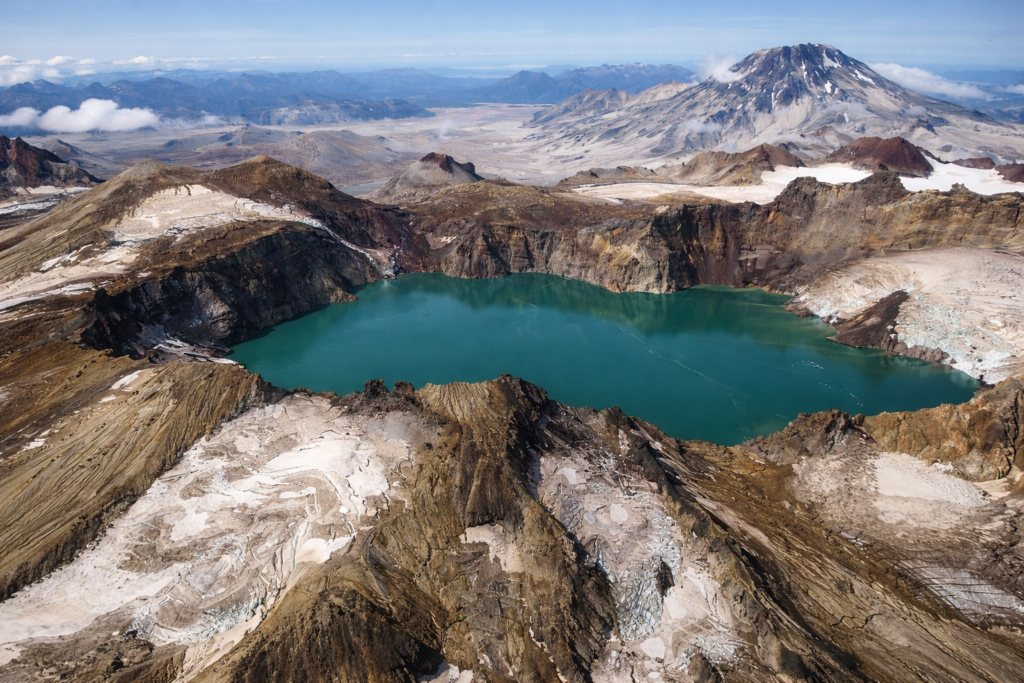
What makes Katmai different is that the mountain itself isn’t the main feature anymore — it’s what’s left behind. During the 1912 eruption, the summit collapsed, forming a massive crater that’s now filled with a deep blue lake. That eruption is considered the largest volcanic eruption of the 20th century, and it reshaped the entire area.
Just nearby is the Valley of Ten Thousand Smokes, a wide landscape of ash flows and volcanic deposits created during that same eruption. Steam vents once filled the valley, and even today, the terrain looks raw and altered, like it hasn’t fully settled.
The mountain is still considered active, though it hasn’t had a major eruption since that event. The surrounding region, however, is part of an active volcanic system, and the ground itself tells that story through ash layers, vents, and unstable terrain.
Access to Mount Katmai is remote. Most people reach the area by flying into Brooks Camp or nearby lodges, and from there, the landscape becomes part of the experience rather than a single destination. You’re not just looking at a mountain — you’re walking through the aftermath of what it did.
Wildlife is a huge part of the area as well. The rivers connected to this region support strong salmon runs, which draw in large numbers of brown bears. It’s one of the best places in the world to observe them, especially around Brooks Falls.
Mount Katmai isn’t about height or visibility. It’s about history and impact. The mountain you see today is only part of the story — the real significance is in what happened here and how it changed the land around